

Route 19: De Rode Loper Stadskanaal
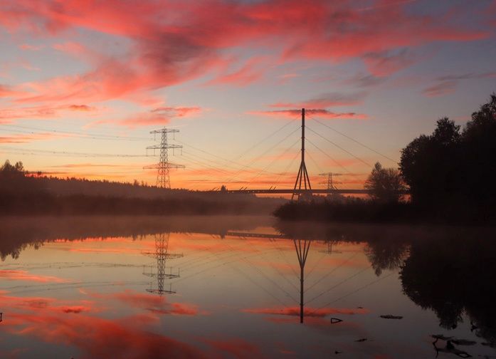
On this route, you walk through the Pagedal recreation area, the Vledder forest and across the Red Run. The route is 11 kilometres long.
On this route, you walk through the Pagedal recreation area, the Vledder forest and across de Rode Loper. This route is 11 kilometres long.
In 1765, the city council of Groningen decided to dig a canal from Bareveld to open up the ...
On this route, you walk through the Pagedal recreation area, the Vledder forest and across de Rode Loper. This route is 11 kilometres long.
In 1765, the city council of Groningen decided to dig a canal from Bareveld to open up the vast bog complex that stretched to the national border with Germany. The canal initially served to dewater the peat bogs and drain the extracted peat. Later, it became the economic artery of the entire region. This function has disappeared and now recreational boating is important. Over time, buildings developed along this canal, eventually leading to today's Stadskanaal. The name clearly refers to the original owner of the canal. The arrival of a Philips plant in the 1950s provided the impetus for the transformation of the peat-colonial ribbon village into the present place with almost urban allure. Stadskanaal has good amenities that make for an attractive living environment. The attention given to public green spaces is striking. Green verges, trees and bushes can be found everywhere.
The walking route passes through the Pagedal recreational area and the Vledderbos. Population expansion in the second half of the 20th century, partly caused by the arrival of Philips, created new residential areas and increased the need for recreational facilities. To this end, Pagedal, which opened in 1973, was built. In 1992, on the other side of the A.G. Wildervanckkanaal and the N366, the Vledderbos was planted. Several viaducts were built to connect with the Westerwold hinterland, and to include the new Vledderbos in the recreation area, the namesake walking and cycling bridge, de Rode Loper, was realised in 1998.
At point 7, along the shell path along the pasture of the Scottish Highlanders in Pagedal, wild orchids can be observed in spring. At the little pond, with decking and beautiful vegetation, the kingfisher has been spotted. Cormorants can regularly be seen at the pond near the kiosk, flapping their wings dry in a row on the poles present in the water. And you can also regularly spot great white egrets there.
The name of the recreation area, Pagedal, is derived from the small river Pagediep, which flows into the Mussel Aa near Onstwedde. The original regional name was (and still is) Poggedaip referring to the many frogs that lived there. Indeed, a pogge is a frog or toad. The curious transposition of the actual name to Pagediep frequently causes confusion in the pronunciation of the name: Page is pronounced with a hard g.
Comments or suggestions? Let us know via the contact form
This is a route of the Walking in Westerwolde Foundation. Sponsors of this route are Pengels Outdoor and Leisure, B & B Bosstee and B & B Vledderstee.
Pengels Outdoor and Leisure: Hoofdstraat 57, Stadskanaal, info@pengels.eu
B&B Bosstee: Johan and Gerda Bos, Waterschapsweg 1, 9595 PC Vledderveen, bb.bosstee@gmail.com, www.bosstee.nl
B&B Vledderstee: Vledderweg 3, 9585 PA Vledderveen, info@vledderstee.nl, www.vledderstee.nl
You are going to see this
Starting point:
Parkeerplaats OnstwedderwegOnstwedderweg
9502 Stadskanaal
Navigate to starting point
Starting point
Parking place Onstwedderweg
Onstwedderweg
9502 Stadskanaal
Navigate to starting point
Features
Walking
- Dogs on a leash Yes
Tour/Route
- Tagged: Yes
- Explanatory marking: Yellow and white stickers with imprint WIW 19
- Route typing: Nature trail
- Route features: From A to A
- Comment starting point: It is also possible to start from the car park at Gedempte Vleddermond, Vledderveen.