


Route 16: Around the Fort Bourtange
This route takes you on a walk around Fort Bourtange. The route is 6.5 kilometres long.
This route is not accessible with dogs.
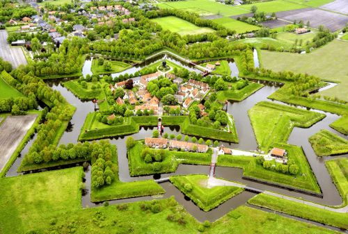
Bourtange was a sand ridge in an immense swampy area, the Bourtanger Moor, and over that ridge ran the only passable road between the city of Groningen and its eastern neighbours. No wonder Diederik Sonoy and Willem Lodewijk wanted a fortress there. They did not deliver by halves: the city of Groningen still rejoices every year over the retreat of the bishop of Münster (Bommen Berend) in 1672. Bourtange never allowed itself to be overrun.
De fort, last fortified in 1742, has a reason...
This route is not accessible with dogs.
Bourtange was a sand ridge in an immense swampy area, the Bourtanger Moor, and over that ridge ran the only passable road between the city of Groningen and its eastern neighbours. No wonder Diederik Sonoy and Willem Lodewijk wanted a fortress there. They did not deliver by halves: the city of Groningen still rejoices every year over the retreat of the bishop of Münster (Bommen Berend) in 1672. Bourtange never allowed itself to be overrun.
De fort, last fortified in 1742, enjoyed a period of relative prosperity thanks to a combination of agriculture, trade, military activity and smuggling. The Jewish community, in particular, contributed to a vibrant retail sector; there was also a market for a time and trade with Germany was always brisk. Jews from across the region came to the synagogue, which was created in 1842 by converting a military barracks. Until the early twentieth century, the Jewish community used a small cemetery, the ‘Beth Chajiem’, which means ‘The House of Life’. It is quite small, and it is believed that a new layer of earth was laid over the original graves. You will pass this site at point 17 on the route. During the war, virtually the entire Jewish population was deported and murdered.
At the Nieuwerksweg is a monument in memory of the Jewish couple Ella and Mozes Braaf (point 6 of the description).
On Nieuwerksweg there is also a gallows field. The gallows are a reminder of a different view of guilt and penance. East Groningen still has a number of old gallows fields or humps, surrounded by stories of witchcraft, torture and execution
Where the Moddermanspad now runs, there used to be the Moddermansdiep, named after engineer Modderman, constructed for the fortifications. This deep drained water into the forecourt to make it marshy and thus impenetrable.
In the first half of the twentieth century, the deep was filled in and trees were planted. In spring, the currant trees on the left side of the path bloom beautifully.
Comment? Let us know via the contact form
This is a route of the Walking in Westerwolde Foundation, sponsored by Camping 't Plathuis.
Camping 't Plathuis, Bourtangerkanaal Noord 1, 9545 VJ Bourtange Tel. +31 (0)599 354383 - www.plathuis.nl - info@plathuis.nl
Here’s what you’ll see
-
Starting point:
Parking place Fort Bourtange
Willem Lodewijkstraat 33
9545 PA Bourtange
Navigate to the starting point -
End point:
Parking place Fort Bourtange
Willem Lodewijkstraat 33
9545 PA Bourtange
Navigate to end point

Features
Tour/Route
- Tagged: Yes
- Explanatory marking: Yellow-and-white marked WIW 16
- Comment starting point: car park information centre fort Bourtange, Willem Lodewijkstraat 33.
Walking
- Dogs not permitted Yes